
JOIN THE CATTLE CREEK CONFLUENCE COALITION
- brianchilbert
- Feb 19
- 5 min read

Defend the Cattle Creek Confluence from irreversible, large-scale development and preserve one of Garfield County’s last critical open spaces
The Land Needs Us Now!
There are moments in a community’s history when silence becomes complicity. The proposed development at the confluence of Cattle Creek and the Roaring Fork River is one of those moments. This is not simply a zoning discussion or another routine planning case. It is a defining decision that will determine whether one of the valley’s last intact ecological corridors remains a living system—or becomes a dense urban footprint that can never be undone.
On February 25th, residents have a rare opportunity to stand together and show decision-makers that this landscape matters. Showing up is not symbolic. It is essential.
Why This Land Matters
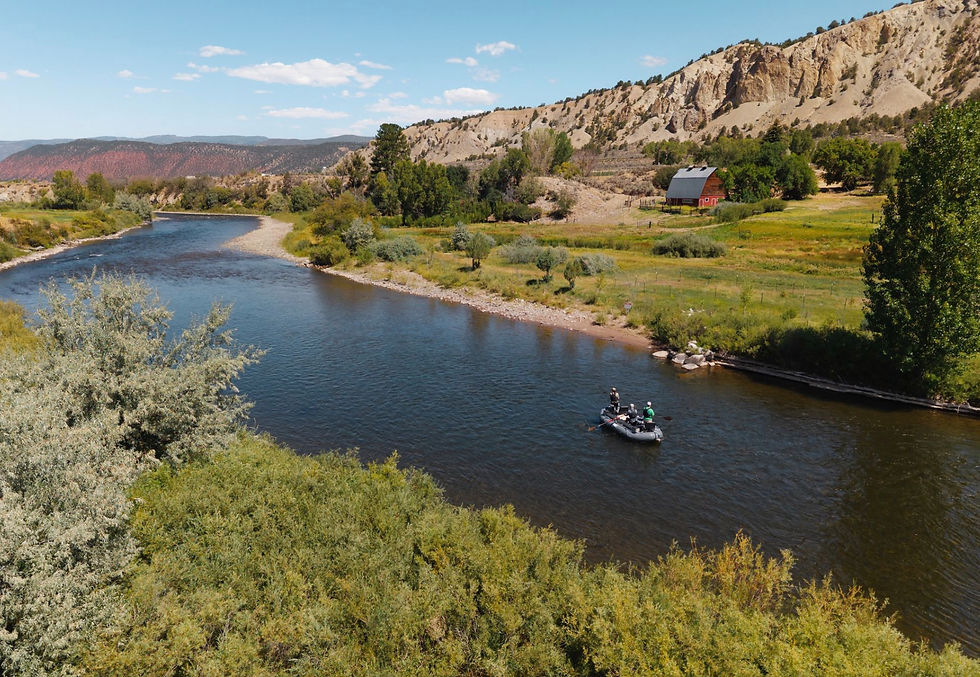
The confluence is an ecological stronghold. Bald eagles nest here. Herons raise their young here. Elk, deer, foxes, migratory birds, and trout depend on this corridor for survival. These are not occasional visitors, they are species whose seasonal movements and life cycles rely on uninterrupted habitat.
Riparian zones like this are among the most biologically productive ecosystems in North America. They filter water, stabilize banks, recharge aquifers, and provide migration pathways that wildlife have followed for generations. When such corridors are fragmented by dense construction, the damage is rarely reversible.
This is not empty land. It is functioning habitat, natural infrastructure, and a shared community resource.

The Development Proposal: A Small City in Rural Landscape
The proposed project by Harvest Roaring Fork LLC, backed by Silverado Interests and Realty Capital, would transform 283 acres into a dense mixed-use complex including:
1,500 residential units
Up to 375 accessory dwelling units
55,000 sq. ft. of commercial space
A 120-room hotel
At roughly 9 units per acre, the density would dwarf surrounding developments. Nearby communities average closer to one unit per 1.5–5 acres. This proposal is not compatible infill, it is an urban-scale project placed into a rural corridor.
Once built, this intensity cannot be reversed. Pavement replaces soil. Traffic replaces silence. Artificial light replaces dark skies.

Native Trout Habitat & Water Quality At Risk
The planned partial damming of the river from August through October to install sewer and gas pipelines could have serious consequences for native trout populations. Construction will likely stir up heavy sediment, clouding the water and reducing oxygen levels, which stresses fish and can smother eggs and aquatic insects they rely on for food. Increased turbidity also absorbs more heat, raising water temperatures at a time of year when trout are already vulnerable to thermal stress. Even more concerning, restricting flows from the colder Fryingpan River will limit the downstream infusion of cool water that normally moderates temperatures and maintains healthy oxygen levels. Together, these impacts could degrade habitat quality, disrupt feeding and spawning, and push sensitive native trout out of one of their remaining strongholds.
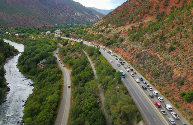
Traffic, Safety, and Infrastructure Risks
The development’s own projections estimate 12,000 additional daily vehicle trips on Highway 82 and that number may be underestimated. The analysis does not fully account for accessory units, the larger hotel size, restaurant traffic, or decades of construction vehicles.
This matters because the intersections near the site are already considered hazardous. Increased congestion means:
Slower emergency response times
Higher accident risk
More pollution
Longer commutes
Construction alone could last until 2042 or beyond, pushing traffic through nearby corridors including Glenwood Springs and along regional routes like Interstate 70. The claim that this project will reduce congestion contradicts both logic and the developer’s own numbers.

Water: The Valley’s Most Precious Resource
Water availability in this watershed is already strained. A development of this scale risks:
Depleting nearby wells and ditches
Increasing runoff pollution
Degrading riparian habitat
Notably, current engineering documents suggest stormwater may be discharged directly into the river system. That means fertilizers, chemicals, and sediment could flow straight into one of the region’s most important waterways.
In the arid West, water is not just a resource, it is the limiting factor for sustainable growth. Any proposal that jeopardizes it deserves intense scrutiny.

Wildlife Corridor at Risk
The project footprint sits inside a known migration corridor for elk and mule deer, as well as seasonal habitat for bears, mountain lions, coyotes, and wild turkey. Dense development fragments these routes, forcing animals into roads, neighborhoods, or unsuitable terrain.
When migration pathways break, populations decline. When breeding grounds disappear, recovery becomes unlikely. Habitat fragmentation is one of the leading drivers of wildlife loss across North America.
Protecting this land protects the entire ecosystem.

Rural Character vs. Urbanization
The zoning designation for this property explicitly calls for low-density development that maintains rural character. A dense complex with buildings up to 65 feet tall and a hotel potentially reaching 80 feet, does the opposite.
The visual impact alone would resemble the skyline density of developments such as Willits near Basalt, not the open agricultural landscape that defines this valley.
Rural character is not nostalgia. It is an economic, cultural, and environmental asset that draws residents, supports tourism, and preserves quality of life.
Public Safety Concerns
Adding thousands of residents without matching investments in fire, medical, and law enforcement infrastructure creates risk for everyone, newcomers and longtime residents alike. Wildfire evacuation capacity is already a concern in the region. Increased density and traffic could make emergency escape routes dangerously congested.
Growth without infrastructure is not progress. It is exposure.
The Illusion of “Conservation Development”
Developers describe the project as a conservation-focused community, citing open-space set-asides and trail systems. But dedicating land while simultaneously surrounding it with nearly 2,000 housing units raises a critical question:
Can habitat truly function when it is encircled by dense urban development?
Conservation is not measured by acreage labels, it is measured by ecological integrity. Fragmented open space surrounded by noise, light, and human activity rarely functions as true habitat.

What’s Truly at Stake
At its core, this debate is about values:
Do we prioritize long-term sustainability or short-term profit?
Do we protect irreplaceable ecosystems or gamble with them?
Do we plan responsibly or react after damage is done?
Once land like this is developed, it is gone forever. There is no restoration that can recreate centuries-old ecological systems or restore lost migration routes.
Why Showing Up Matters
Public meetings shape outcomes. Decision-makers look at attendance, testimony, and community engagement to gauge how strongly residents feel. A packed room sends a message that cannot be ignored:
This land matters. This community is paying attention. This decision has consequences.
If you care about wildlife, water, safety, traffic, rural character, or the future of this valley, your presence on February 25th is one of the most powerful actions you can take.
Meeting location:
Wednesday, February 25, 2026 at 6:00 p.m.
Colorado Mountain College - Spring Valley Campus
3000 CR 114
Glenwood Springs, CO
81601
A Call to Stand Together!
The Cattle Creek Confluence is not just a parcel on a map. It is habitat, watershed, history, and identity woven into one landscape. Protecting it is not anti-growth, it is pro-responsibility. It is about ensuring that development respects ecological limits and community values.
The question is no longer whether this place is worth defending.
The question is whether we will show up to defend it.
Join the Coalition. Attend the meeting. Speak for the land that cannot speak for itself.


Comments